


Leveraging Leidos
Making the Most of Your Online Flight Service Weather Briefing
By Tom Hoffmann, FAA Safety Briefing Magazine Editor
As a child of the 70s, I had a front-row seat for some pivotal periods of the information age. When I reflect on my first real office job, the centerpiece of my computer-less desk was an old beige analog phone flanked by a never-ending mound of paperwork and sticky notes. I look back on those times with a certain amount of fondness, reveling in the ability to stay laser-focused on my duties and use the phone as a primary means to conduct business. There were no emails, websites, or viral cat videos to distract us from the tasks at hand. But in what seemed like the blink of any eye, the personal computer, followed soon by broadband internet, simultaneously enabled and disabled certain aspects of work and life as we knew it.
The transition gave us instant access to troves of information, but it also overwhelmed us with choices. That seems to describe life for many people today, even more so thanks to the supercomputers we carry around in our pockets that incessantly vie for our attention.
Pilots are familiar with the plight of information overload. Glass cockpit technology has modernized the way we fly and can convey multitudes of information about what’s happening with our airplanes, even predicting what could happen. Processing that data can be like drinking from a firehose, and it’s tricky business for a pilot already task saturated. But as Clay Shirky’s quote points out, it’s a matter of discipline to leverage the right sources of information and filter out what we really need.

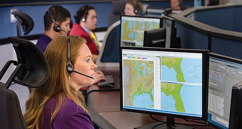
A good example is the preflight weather briefing process. Most pilots are not meteorologists, so the plethora of available weather information can cause “analysis paralysis,” especially with the migration towards online self-briefings. The folks at Leidos Flight Service, the FAA contractor that handles flight service duties for the continental United States, know how important it is for pilots to get the essentials they need to make sound go/no-go flight decisions. Leidos’ website, 1800WXBRIEF.com, has evolved significantly in recent years to give pilots greater access to the information they need and when they need it, but in a way that also doesn’t make your brain explode. Allow me to highlight a few features that will help you be better prepared and more familiar with all available resources for your next flight.
You Had Me at Login
First things first. If it’s been a while since you’ve visited 1800WXBRIEF.com, or if it’s your first time (welcome!), you’ll want to make sure you can log in. This is important as the site is only partially accessible until the user has logged in and, in some areas, tracks and records user activity to the Pilot History page. This history remains for 45 days and provides evidence that you received a weather briefing — a nice thing to have in your back pocket. New users can register by clicking the Create Account link on the home page. If you already have a call-in profile set up with Flight Service, the system will link that information to your new web account. Once logged in, your dashboard page will appear and get you on your way.
“It’s not information overload. It’s filter failure.” — Clay Shirky
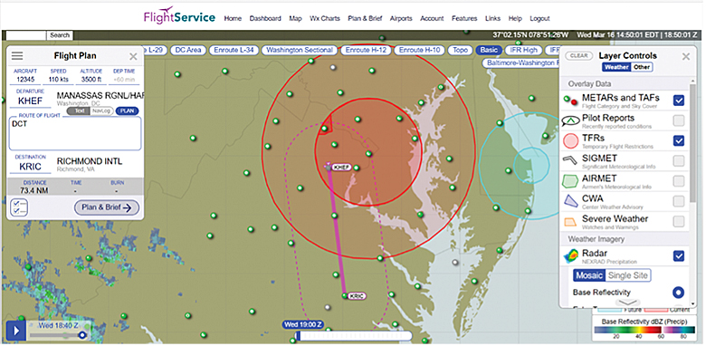
The interactive map is one particular area of the website that Leidos Innovation and Outreach Director Jeff Arnold likes to showcase. “It’s one-stop shopping for weather briefing and flight planning that you can view side by side,” explains Jeff, referring to the flight plan mask that appears once you’re on the interactive map page. Simply type your departure and arrival airport in the flight plan box. A direct route of flight (magenta line) will display on the map along with NEXRAD precipitation imagery, nearby Meteorological Aerodrome Reports (METARs), Terminal Area Forecasts (TAFs), and Temporary Flight Restrictions (TFRs). Using the layer control button in the upper right corner, you can toggle several other layer tools on and off (stacked white squares icon). These include AIRMET/SIGMET weather advisories, cloud imagery, turbulence, icing potential, and much more. There are also several map backgrounds to choose from beyond the basic default, like a VFR sectional, IFR en route charts, and aerial satellite views.
The interactive map feature of 1800WXBRIEF.com lets you easily see weather and information relating to your plotted route of flight. Toggle through the layer controls (right side) to show different overlay data, like METARs, TFRs, and mosaic radar imagery.
Getting Some Local Flair
Another awesome and somewhat overlooked feature of layer tools is the vaguely named “Other” section, directly adjacent to the weather layers. This section gives pilots unique insight into local area conditions. It is based on pilot feedback after Leidos consolidated its briefer locations. With a series of options, pilots can explore local weather phenomena and potential aviation hazards that were once the domain of local briefers.
“To capture this valuable local area knowledge, we took the material we use to train our briefers, then uploaded, categorized, and placed it on the map. There’s a lot of good-to-know information on there that you won’t find anywhere else,” says Jeff, who notices many a raised eyebrow during presentations of this feature.
It’s an excellent idea to explore these area knowledge options, especially if you’re flying through unfamiliar territory. You’ll see topography and aviation hazards, like high-volume flight school activity areas (yellow boxes), and how land features like mountain passes or plateaus can affect weather in a specific region. You can even click on an individual state to view the major weather makers or see how the climate in that area varies by season. There are also helpful overlays of common military training routes and special-use airspace like prohibited or restricted areas that are sometimes hard to discern on a sectional. Think you might need the help of Flight Service in flight? All Flight Service Station, Air Route Traffic Control Center, Approach, and Automated Surface/Weather Observing System (ASOS/AWOS) frequencies you might need on your route of flight are available with a click.
“This area knowledge feature serves as an excellent teaching tool for flight instructors, too,” adds Jeff. “You can easily show students what all these areas look like and how they could affect the safety of flight.” That’s not to mention the importance of getting students to appreciate the value of the Leidos website at an early stage. I wish I had had such a detailed resource during my training.
One last feature of the interactive map worth noting is the briefing checklist available on the flight plan overlay (button with two small checkmarks). The checklist will take you through all of the different layers and features mentioned earlier in a more methodical manner. Note that every filter you choose gets logged into your pilot history. The checklist can be customized to best suit your needs and includes several weather charts to aid your weather research efforts.
Sounds Like a Plan
The weather for your trip looks good, so your next step is filing the flight plan. Leidos makes that part easy as well. From the flight plan mask, click the Plan & Brief button to bring up an electronic ICAO flight plan form. To help save time, all of the info you fill out on the map will carry over to the form. Leidos makes filling out the rest as painless as possible, with help fields to guide you. Just hover over each section title of the form for tips on the required input or the magnifying glass to search for and select items. For example, you can choose your specific make/model of aircraft from a stored list and choose aircraft and surveillance equipment types from a checklist. Tip: By entering your aircraft information beforehand into your account, the form will provide you with an estimated cruising speed, time en route, and an optimized altitude based on your flight details.
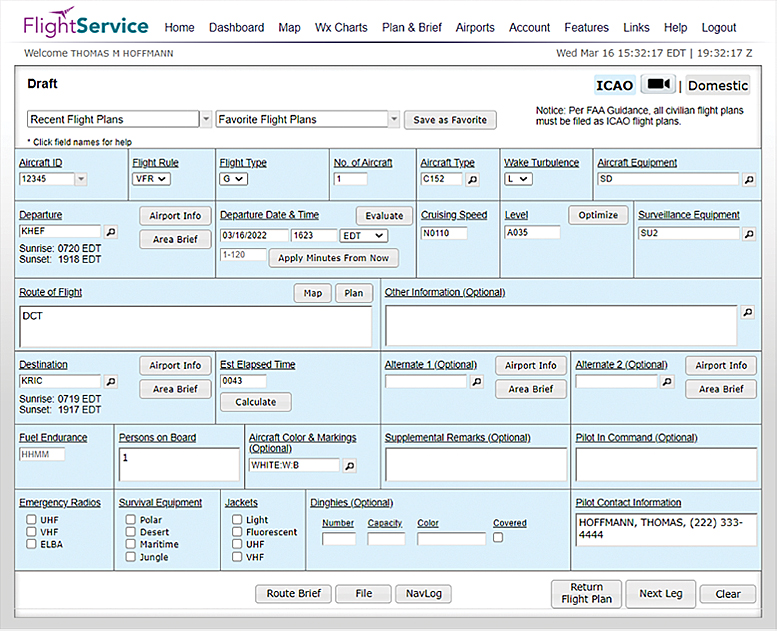
The electronic ICAO Flight Plan Form has several features to help make filling out the form faster and easier.
To further help with go/no-go decisions, the flight plan form’s Evaluate Departure tool lets pilots enter a departure time (Zulu time is converted for you) and view a list of additional departure windows along with the estimated route conditions for those times. It lets you easily see how you can avoid marginal VFR conditions or convective activity by delaying the departure time. Click on each proposed time slot for more detail and to view TAF stations along your flight route.
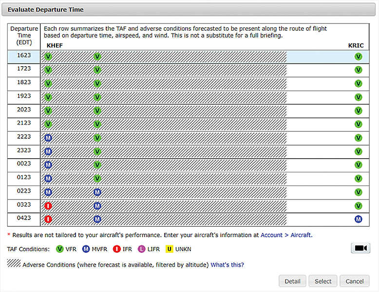
To help with go/no-go decisions, the flight plan form’s Evaluate Departure tool lets pilots view a list of additional departure windows along with the estimated route conditions for those times.
Do you need weather info and charts for your departure, destination, or alternate stations? Click on the Airport Info or Area Brief buttons next to any of these items on the flight plan form. You can also customize your route of flight by using the Plan button adjacent to the Route of Flight field. Once you’re done with the form, use the buttons at the bottom to customize a weather briefing for your chosen route, file your plan, and create a kneeboard-sized navigation log to take on your flight.
Watch this video to learn more on the ICAO Flight Plan form on the Leidos Flight Service website.
Right-Sized for Everyone
With our growing dependence on mobile technology, it’s a given that Leidos made platform scalability a high priority. “When we say we’re mobile-friendly, we’re not joking,” quips Jeff. He adds that it’s rare to see any device-related complaints but that you are limited to the screen size of your device. There is an option to switch to the full desktop version on a mobile device if that’s preferred.
Another feature for smartphone users is the ability to text Flight Service at 358–782 or FLTSVC to get METARs, TAFs, and adverse condition reports. You can also use the EasyActivate & EasyClose email or text messaging features to activate and close your flight plan. And if you’ve got an at-home smart device (e.g., Alexa, Google Assistant), try using it to retrieve METARs, TAFs, and Aviation Forecast Discussions. (This PDF guide can help with setup.
Leidos is firmly committed to updating and improving the features and functionality of its website and services. At the time of this writing, Leidos issued a notice outlining several new web enhancements, including the addition of ASOS/AWOS and FSS frequencies to navigation logs, the ability to amend flight plans with ATC route changes via text (Easy Amend), and something pilots have been eagerly awaiting, the ability to filter out Flight Data Center (FDC) NOTAMs from briefings. The complete list of website updates is available here.
Free and Easy
While there are simply too many features of the Flight Service website to highlight in this article, I hope this high-level tour provides a few pointers and reminders that can help you leverage this vital weather resource with greater efficiency and success.
“We realize most GA pilots are uncomfortable with the weather,” says Jeff. “But we’re here, and we’re free. So go online, check the weather, and if you have questions, call us.”\
According to Jeff, the best way for pilots to genuinely tackle weather issues is to get their hands on the weather information and make a run at doing regular self-briefings. The more you get used to using the tools and seeing what’s available, the more weather wisdom you’ll accrue and the better prepared you’ll be for your next flight. Of course, pilot feedback is critical to ensure continued success, so be sure to let Leidos know what you think at bit.ly/LEIDOSFeedback. Blue skies and tailwinds!
Learn More
- Leidos Flight Service Web User Guide (PDF download)
- Advisory Circular 91–92, Pilot’s Guide to a Preflight Briefing
- FAA Safety Team Course ALC-683, Conducting Preflight Self-Briefings for VFR/Student Pilots
- “The Century Club: 100 Years of Flight Service,” FAA Safety Briefing— May/Jun 2020
Tom Hoffmann is the managing editor of FAA Safety Briefing. He is a commercial pilot and holds an A&P certificate.
Reprinted with permission from FAA Safety Briefing. Visit the Flight Safety Briefing website: https://www.faa.gov/news/safety_briefing/.