


When Is the Last Time You flew An ILS Approach?
By Michael J. “Mick” Kaufman

With the advent of GPS just several decades ago, many of us have not flown an ILS approach in quite some time. As our avionics continue to improve, many pilots have panel updates scheduled or in progress, and in some cases, these panel updates cost more than the airplane cost when it was originally purchased. I have been doing ILS approaches since I earned my instrument rating almost five decades ago. ILS approaches have several shortcomings.
The ground equipment for the ILS is very expensive for the FAA to install and maintain, but the equipment we need in our airplanes to successfully fly an ILS approach, can now be purchased for less that $1,000. Because the ILS equipment is so expensive from the government side, you find them only at major airports and only for one or two runways. As far as I know, no GPS approach has lower minimums than ILS approaches; however, those zero-zero approaches require additional equipment and special pilot training.
To fly an ILS approach, we need an ILS receiver, which is usually part of an old VOR receiver and a glideslope receiver which may or not be part of that VOR receiver. A new $70,000 panel upgrade will not do a better ILS approach than an old King KX-170 did five decades ago. We as pilots need to know that there are a few shortcomings to both the ILS approach and a GPS approach to be discussed below.
Some twenty-plus years ago, I was returning from Florida in my Bonanza and checked the weather for the home airport, Lone Rock WI (KLNR). It was not good, and the only approach available at that time was a VOR A approach with high minimums. So, I decided to divert to Dubuque (KDBQ) for the ILS 31, which also had low IMC conditions. I was being vectored for the approach by Chicago Center as there was no approach control at Dubuque. I checked ATIS, set my altimeter 29.62 and intercepted the localizer on a vector. The glide slope came alive, and I was on the approach. I always check my altimeter when crossing the final approach fix against the published altitude on the approach plate. If this is not one of your procedures when flying an ILS approach or GPS approach, you could be a candidate for disaster.
As I crossed the final approach fix on the glideslope, I realized I was some 360 feet below the published crossing altitude shown on the approach chart. Not good! Now on the tower frequency with a cleared to land clearance, I immediately declared a missed approach. I asked the tower for the current altimeter setting and was given 29.26. I must have set in the wrong altimeter setting. I was switched back to Chicago Center and was vectored back for another approach. This time, everything checked crossing the final approach fix, and I landed without further incident. I taxied to the ramp and shut down the engine and avionics, but something bothered me — how could I have made such an important mistake? I decided to turn the radios back on and listen to the ATIS again. What I found was when the controller made the ATIS tape he transposed the altimeter setting from 29.26 to 29.62. I called the tower and asked them to listen to the ATIS tape, which he did, and then acknowledged his error. If I had followed the glideslope correctly to published minimums without seeing anything, I would have been 160 feet lower than I thought I was–lesson learned.
Several years later while training a pilot for an instrument rating doing the same approach at the same airport, a similar situation happened, but in VFR conditions. Again, I called the tower for an altimeter setting, but this time it matched the ATIS, so we landed. I figured it was another similar error, but after landing, the altimeter matched the touchdown zone elevation. How can this be? So, I called the avionics shop, and they had us bring the airplane to the shop. The glideslope was out of calibration, so it was recalibrated, and everything worked correctly. Every two years we have a pitot static, altimeter and transponder check done on our airplanes. When flying IFR using VOR for navigation, we as pilots must do a VOR check and log it in the aircraft records, but nothing is said about the localizer or glideslope. I learned that the localizer and VOR use different electronic circuits, and the VOR check means nothing to the localizer.
When we look at some of the differences between ILS and RNAV/GPS approaches, we need to be aware of the accuracy of the approach. To the surprise of many of you, the ILS approach, which has been around for about 75 years, is still the winner. We have implemented WAAS which has greatly improved the accuracy of GPS approaches, but it still can’t be as accurate as the ILS approach. This is due to the weather conditions such as temperature and humidity that affect the radio signals from the GPS satellite.
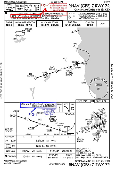
You may see notes on approach plates FIG 1 & 2 that tell us VASI may not align with the approach course, or the approach cannot be done if the temperature does not fall between the guidelines needed for obstacle clearance. Below we can see a description of the two services, though both will provide an obstacle-clear path to the runway.
“A precision approach is an instrument approach based on a navigation system that provides course guidance and glide path deviation meeting the precision standards of ICAO Annex 10. For example, PAR, ILS and GLS…
Approach with vertical guidance (APV) is an instrument approach based on a navigation system that is not required to meet the precision approach standards of ICAO Annex 10 but provides course and glide path deviation information. For example, LNAV/VNAV and LPV are APV approaches.”
When we fly the ILS approach today, it is the same as we did it fifty years ago. The difference being how we get established on the approach. We do not need to have any GPS in the airplane to fly the ILS approach, as we did not have GPS back then. Once established on the inbound course, we fly localizer and glideslope. As discussed in a previous article, if we are hand-flying the approach, we learn to dance on the controls to keep those needles in the center, especially in turbulent air.
When we are being radar vectored for the approach, no GPS is needed, and it might be better to not use any GPS for reference. I will explain later. During the radar vector, the controller will specify or should specify that this is a vector for the approach and will specify the runway on the first vector he/she has given you. The last vector will include an altitude and heading until established along with the approach again for pilot verification. This requires a total readback from the pilot, heading till established, altitude and the name of the approach.
When we are going to be flying an ILS approach with radar vectors and without using GPS assist, there are some “Gotchas” to remember. Before GPS, I had a lot of fun with instrument students on this type of approach.
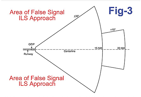 There are false signals from the localizer and glideslope that will trick the pilot into thinking they are on the proper signal FIG 3 so you must fly to the initial approach fix, positively identify it, and then fly the charted approach as depicted on the approach chart.
If you are using GPS assist and flying the full approach with a course reversal, you will not even be aware of these false signals because you are in GPS mode on your navigator. It is important when either loading the approach or activating the approach the first time to make sure you load the ILS frequency from the standby window to the active window on the navigator. I recommend that pilots go to settings on their navigator while on the ground and select the option to manually switch from GPS mode to VLOC mode for ILS approaches. The GPS does a much better job of getting the airplane correctly established on the inbound course as the auto switch occurs once inbound on the procedure turn. Autopilots flying roll steering (GPSS) do a much better job getting established on the inbound course than trying to capture a localizer signal in VLOC mode.
The last configuration on flying an ILS approach, which I mentioned earlier in this article is using GPS assist when getting radar vectors and why this could fool the pilot if they are unaware of how it works. You have been told by ATC that you are getting radar vectors for an approach, so you load the approach, put the ILS frequency in the active window and then select vectors to final on your GPS navigator. ATC starts vectoring you and suddenly you notice that your navigator shows “suspend” kind of like in a holding pattern. This does not always happen as it depends where you are in relation to the inbound approach course. As you follow the vectors from ATC, you notice the navigator is still in “suspend” and you know that pushing the OBS button takes you out of “suspend.” It is tempting to push that button, but don’t do it, as it will come out of “suspend” automatically at the proper time. Doing so will cause the box to sequence to the next waypoint and this would be bad. Remember when using the GPS navigator on vectors to final, there will be no magenta line to follow until on the inbound approach course.
Fly the ILS approach when offered to you the next time there is an option for the landing runway to help you keep current. Better yet, practice with a safety pilot or instructor before you tackle it in IMC conditions. As part of our training at BPT flight clinics, you get the chance to practice one.
‘Til next issue of the Captain’s Corner, Fly Safe!
Mick