

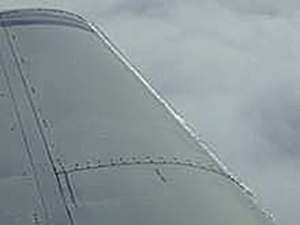
When an aircraft is flying near the top of the cold air mass beneath a deep layer of warm air, serious icing can occur.
- Conditions that make icing worse:
- Any freezing precipitation
- Freezing rain / drizzle / sleet
- Very wet conditions
- High cloud tops – buckets of water
- Maritime air
- Great Lakes / northwest
- Top 20% of the cloud height
- Unstable air
- Over mountains: mechanical lifting / wave action
- Frontal action: building cumulus
- Any freezing precipitation
- Conditions that relieve icing situations:
- Very cold: moisture is mostly frozen ice crystals
- Sunshine: Sublimation occurs even below freezing
- Fairly dry: Ice usually not too bad in stratiform
- Rain [above freezing]: Peels off ice quickly
- Air [above freezing]: Melts ice off slowly
- High RPM: Ice accumulates more slowly on prop
- Necessary ice strategies
- Get a good weather briefing
- Can detect possibility of freezing rain
- Get the big picture and WX at every point
- Can craft 100% our plan [or not]
- FSS is usually fairly conservative
- Pilot reports for “NO GOs”
- Bad reports from larger aircraft
- Unattainable tops
- Pilot reports for “GOs”
- Reports of no ice; can be timely
- Reliable local tops info
- Correlate with other WX data
- Have plenty of fuel
- Increases options
- Decreases ROC
- Get a good weather briefing